Please select your home edition
Edition
Maritimo 2023 M600 LEADERBOARD

C-MAP launches Web Map Tiling Service (WMTS)

by Andrew Golden 7 Jan 2020 21:39 PST
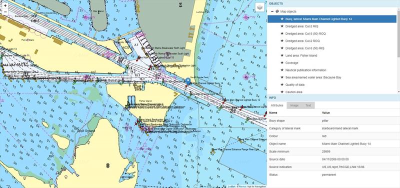
C-MAP Web Map Tiling Service (WMTS) © Andrew Golden

C-MAP, a leader in digital marine cartography and cloud-based mapping, announced today the launch of the C-MAP Web Maps Tiling Service (C-MAP WMTS) for developers.

C-MAP WMTS, available via developer.navico.com, allows companies to build their own map-aware applications based on a worldwide collection of C-MAP marine charts from Navico. The tiled Professional+ database has scale ranging from an overview of the entire world to highly detailed coastal and harbor charts. The chart and value-added data originates from official government bodies and commercial companies, and is produced, controlled and regularly updated by Navico's professional cartographers.

Designed using Open Geospatial Consortium Standards (OGC), C-MAP WMTS is an excellent solution for web-based services such as AIS tracking, customer portals and situational awareness. In addition to the detailed database of charts, C-MAP also offers developers an extra weather forecast overlay, which includes barometric pressure, temperature, wind, precipitation total and swell waves. The weather service overlay is offered as a 15-day forecast package. It is also possible to combine charts with other geo-spatial value-added data.

C-MAP WMTS is ideal for companies developing applications for external clients connected to the internet and those that require marine charts on proprietary internal applications, such as shipping companies with their own vessel tracking systems. Registration on the developer portal is free.

For more information please reach out to

Related Articles

C-MAP updates cartography for North America
New data includes satellite imagery improvements in over 19 states C-MAP®, a leader in digital marine cartography and cloud-based mapping, today announced a major update to its North America charts, introducing detailed data for hundreds of lakes, improved satellite imagery, enhanced shaded relief and more. Posted on 26 Feb
C-MAP app now with crowd-sourced Genesis layer
As well as across Lowrance®, B&G® and Simrad® apps powered by C-MAP charts C-MAP®, a leader in digital marine cartography and cloud-based mapping, has made its crowd-sourced mapping data called “Genesis” available on the C-MAP navigation app this month, as well as across Lowrance®, B&G® and Simrad® apps powered by C-MAP charts. Posted on 23 Jun 2022
C-MAP announces launch of new website
Featuring rich content covering the entire C-MAP range C-MAP, a leader in digital marine cartography and cloud-based mapping, announced today the launch of the new C-MAP website catered to recreational boaters. Posted on 18 Jun 2020
C-MAP announces Tennessee Precision Contour HD
1-foot contours and custom color depth shading will help anglers find and catch fish easier C-MAP, a leader in digital marine cartography and cloud-based mapping, announced today the release of the second offering in its series of digital fishing map cards, Precision Contour HD – Tennessee. Posted on 25 Jan 2019
C-MAP launches Embark AIS overlay functionality
See boats around you in real time C-MAP, a leader in digital marine cartography and cloud-based mapping, announced today the launch of new AIS functionality for the Embark navigation app. Posted on 20 Dec 2018
Maritimo 2023 S-Series FOOTER