
NOAA Buoys help fishermen strategize in real time
by NOAA Fisheries 14 Dec 2017 06:55 PST
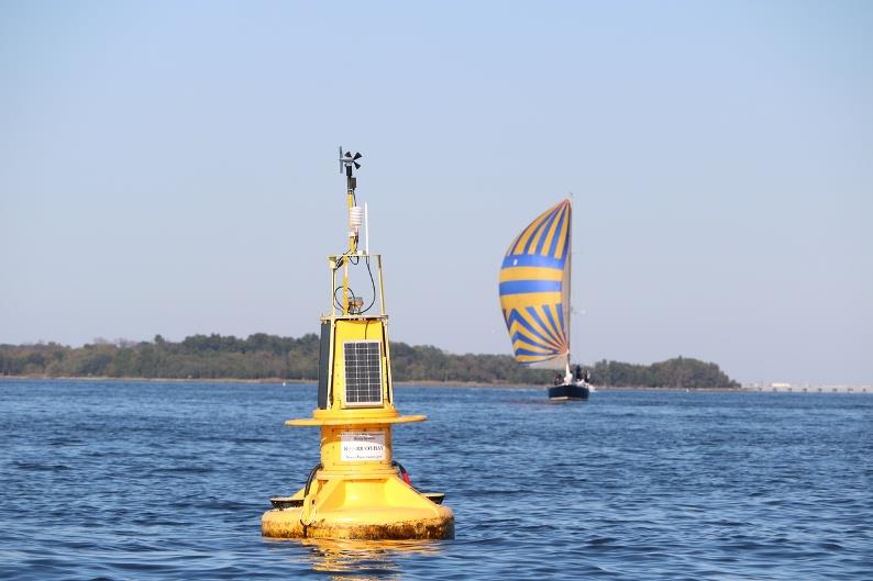
NOAA Buoys help fishermen strategize in real time © NOAA Fisheries
In this age of open data, a wealth of up-to-date and user-friendly information is just a few clicks away. But what does this digital revolution mean for U.S. fisheries? In the Chesapeake Bay, NOAA Fisheries buoys help marine scientists, fishermen, and others to better manage, protect, and enjoy the Bay's marine resources.
The 10 buoys in the NOAA Chesapeake Bay Interpretive Buoy System (CBIBS) use cell phone and internet technology to share real-time data about the Bay's weather and water with the public. Many CBIBS users access data from this network of observation buoys through the website or the "NOAA Smart Buoys" free smartphone application available via Google Play and the App Store. These free apps make it easy for Bay users to select a buoy and get information on wind speed, water and air temperature, wave height, and water quality at their location.
With these data, commercial and recreational fishermen can plan a safer day by knowing the conditions on the Bay before they leave harbour. CBIBS also offers fishing-friendly data not found in other apps. Past and current readings on barometric pressure, dissolved oxygen, sea nettle probability, salinity, and turbidity, or the level of the water's murkiness, help anglers like Rich Dennison better prepare for trips and make strategic decisions while on the water.
"CBIBS is a go-to resource for me," says Dennison, who is store manager at Tochterman's Fishing Tackle in Baltimore, Maryland, and striped bass trolling enthusiast and teacher. "When I'm planning a fishing trip, I'll look for patterns in CBIBS' data history. Is the water temperature increasing? Is the salinity of the water on the rise? What is the level of dissolved oxygen? CBIBS is extremely useful for helping me decide what areas to target or avoid based on the fish's typical behavior in these different conditions."
CBIBS' real-time data is valuable for marine scientists' work as well. Having access to a well-maintained system with up-to-date information that CBIBS delivers means researchers can provide stakeholders more robust predictions of the Bay's water quality. For example, John Jacobs, a researcher at the Cooperative Oxford Laboratory—a NOAA National Ocean Service lab in Oxford, Maryland—is studying a certain species of Vibrio bacteria. The bacteria occurs naturally in our coastal waters but can also cause serious wound infections.
Working with state health officials and academia, Jacobs and his team have developed a predictive model based on water and weather conditions to better understand where in the Chesapeake Bay the Vibrio bacteria will occur. They use CBIBS data on the current conditions in the Bay to improve their forecasts. "CBIBS is an essential component of our modeling system and allows us to consistently maintain the accuracy of our predictions," Jacobs noted. With all the time they spend on the water, fishermen will certainly benefit from this knowledge.
A safer Bay, thanks in part to CBIBS, can only mean good things for this highly valued regional resource. The commercial seafood industry in Maryland and Virginia, which relies on the Chesapeake Bay as well as waters in the Atlantic, contributed $2.8 billion in sales and supported 22,950 jobs in 2014, while their recreational fishing created $551 million in income and supported 12,939 jobs.
To learn more about how these buoys work, check out an interactive graphic.
CBIBS is operated and maintained by the NOAA Chesapeake Bay Office. To learn more about how others use CBIBS, and to see current conditions around the Chesapeake Bay, visit the CBIBS website.